
Origins of the Village of Waterford Through 1845
Many books have been written exploring the geological and political origins of Wisconsin. Here is a brief synopsis of events that led up to the establishment of the area now known as the Village of Waterford – much of it written in The History of Racine and Kenosha Counties, published in 1879,1 but without the corroborating documents. Other resources were consulted to enhance the surrounding events.
1800 – United States government acquires a large tract of land that today encompasses Michigan, Wisconsin, Iowa and Minnesota.
1809 – A new territory of Illinois was established which included Wisconsin.
1818 – Illinois becomes a state. Wisconsin becomes part of the Michigan Territory.
1833 – Treaty signed with Pottawatomie, Ottawa and Chippewa tribes to cede the now southeast part of Wisconsin in the Michigan Territory to the government. It did not allow for full-scale immigration to this area for three years. During this time, it allowed the Indians to relocate west of the Mississippi River and the government was to survey the land to make it ready for settlement.5
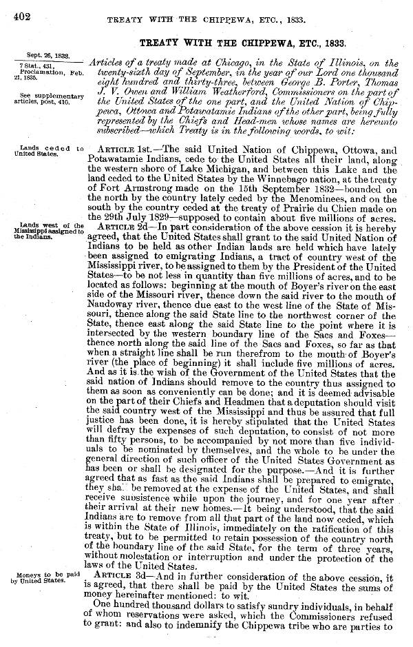
Note: (Ref. 8) The complete treaty can be found at this LINK.
1836 – Michigan becomes a state.
April 20, 1836 – Wisconsin is made a territory which also includes the northeast corner of Illinois, Iowa, Minnesota, and part of the Territory of Dakota. The counties established in the territory were Brown, Milwaukee, Iowa, Crawford, Dubuque and Des Moines.
1832 – May 18362 – Bitten by the “Western Fever,” 25-year-old Samuel E. Chapman, a practicing lawyer in Batavia, New York, and his 62-year-old, father-in-law, Levi Barnes, an itinerant preacher and farmer, emigrated from Upper New York State seeking cheap government land that offered more opportunities to prosper. Land was expensive in upper New York and promised little hope of developing opportunities.
Mary Chapman Jordan, Chapman’s youngest daughter, wrote a short biography of Chapman which was recently found in the Walter Leach Collection at the Wisconsin Historical Society. She states “In 1832, (Nov 25th) he was married to Harriet Barnes, one of the daughters of Levi Barnes, whose family of two sons and 4 daughters all married – went by way of the Great Lakes and settled in LaPorte and South Bend, Indiana.”
Previous authors have written that the pair probably stopped at Jambeau’s Trading Post in Skunk Grove, just west of the Racine settlement, to make inquiries about suitable waterpower in the area. They were told to follow the Indian trail they were already on – about a day’s ride west. There, they came across the Fox River and decided to stay since it had great potential for development.
A story is written about Barnes and Chapman spending the night by the Fox River. Upon waking, they discovered their head bandanas missing, apparently taken by mischievous Indians. Barnes, declared that it was a sign from God that this would be the place to settle5..
Early settlers, Levi Godfrey and John Wade, preceded them about six months earlier to about a mile down the river, in today’s Village of Rochester, to harness the power at that point.
Chapman and Barnes would “stake their claim” of 320 acres, a half section, using the common method of the day – a pocket compass, pacing, and an axe to blaze the marker trees while carving their names and date on the corners. A small cabin was required to hold a legal claim. It was a crude documentation method but claim overlaps were usually worked out without litigation. After “staking their claim,” Chapman and Barnes returned to Lockport, Indiana, to retrieve their families.
The word ‘claim’ was used by pioneers to denominate both the tract of land selected and the right to hold the tract. Interference with rightful claims was termed ‘jumping’ and claim-jumpers were looked upon with abhorrence by all good citizens. It was deemed extremely hazardous as well as highly dishonorable for a speculator or stranger to bid on a claim even though it was not protected by a ‘pre-emption’ right. More than one ‘war’ was waged when such attempts as that were made, almost invariably resulting in the rout(sic) of the interloper. Blood, in some instances, was shed in defense of their recognized rights.1
Further information is contained in the OUR FOUNDERS section of this website.
October 1836 – The First Territorial Legislature established 15 counties which included Racine, Walworth, Rock and Jefferson comprising the southeast part of Wisconsin. Iowa was made a separate territory.
1837 – During the time Chapman and Barnes were gone to reunite with family, a “Mr. Beebe” made claim to the water power and built a shanty. Upon his return, Chapman bought the rights from him for a reported $700.1 As his first settlement project, Chapman, with the assistance of eight other local farmers, dammed the river and built a sawmill in the Fall. Lumber was needed to build dwellings and business buildings. Wood was very plentiful and the land needed clearing to grow crops. An excerpt from “The letters of Edwin Bottomley, 1842-1850” tells of the logging activity using the Fox River for the conveyance of timber. “…and in proof of which I can state that theire (sic) are no less than 4000 logs lying at the sawmills of Waterford and Rochester, and in the river ready for rafting down when the ice breaks up and the greatest part of these have been cut from Government land.”12
January 2, 1838 – The territorial legislature splits up Racine County into townships with no special reason other than local advantage and convenience.1 Township 4 became the Town of Rochester.
1839 – A flour mill with a 22-inch stone was built next to the sawmill. It would become Chapman’s primary business for most of his life while continuing to practice law.
The Great Land Sale of 1839, which Congress authorized to allow people to buy government land for $1.25 per acre ($41.71 in 2024 dollars), put many in a frenzy. Initial ownership of the land by a private individual was called a Land Patent, meaning “the first.” The Government Land Office was opened in Milwaukee to auction off land in the territory. Bidders had to be there in person or have a representative agent buy the parcel when it came up for sale.
The process began with an announcement made from the steps of the courthouse stating which parcels were being offered for sale. There was no pre-emptive provision in the law that protected the settlers’ rights, some of whom had invested all their money and work into developing a farm which vastly increased its value. But, they may have become land rich and cash poor. Settlers were required to pay cash to buy the property that they had already claimed.
It was common to use an agent, or representative, to buy the property, and he in turn, might sell it back to the settler at an inflated price of two times or more, plus a bond with interest not uncommonly set at 12 to 25 percent or more. Some of the settlers appointed another trusted settler to speak up for them to make the claim, but, at the end of the day’s auction, they still needed the money to pay for the land.
If the settler wasn’t there to claim his piece of property, a speculator quickly spoke up. This intrusion would not be treated kindly. At times, it was a raucous event since there was a lot of speculation and prices could skyrocket. Several written accounts relay incidents of speculators getting physically assaulted then carried out unceremoniously on the shoulders of concerned settlers and dumped in the street.
The auction process went on for quite some time. The hospitality business in Milwaukee was running wide open with settlers eager to learn when their property would come up for bid. Purchasing the land would end their fears of losing their land to a claim jumper or speculator. It was an anxious time for all the settlers that took a chance to develop some land which legally wasn’t theirs until it was purchased from the government.
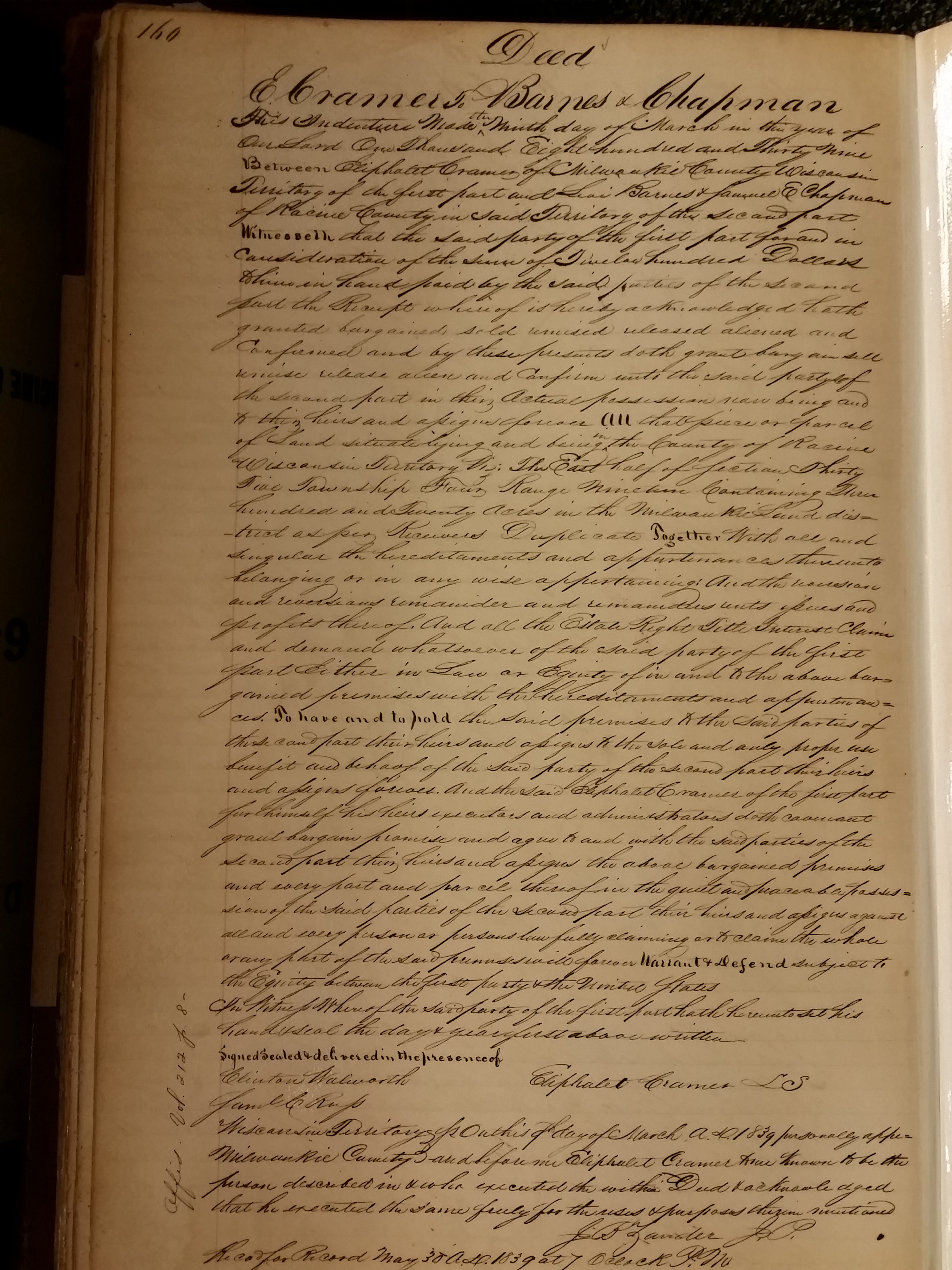
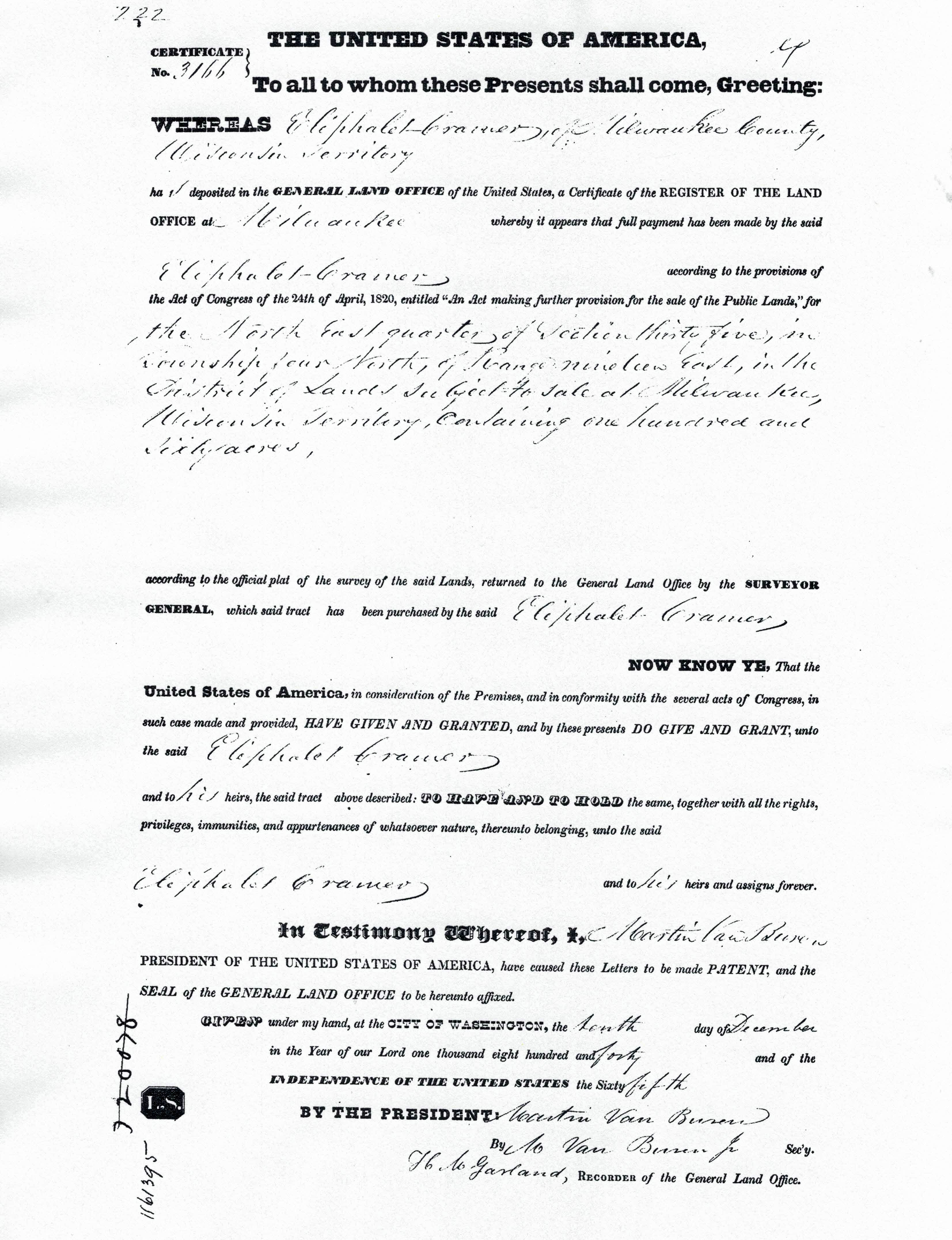
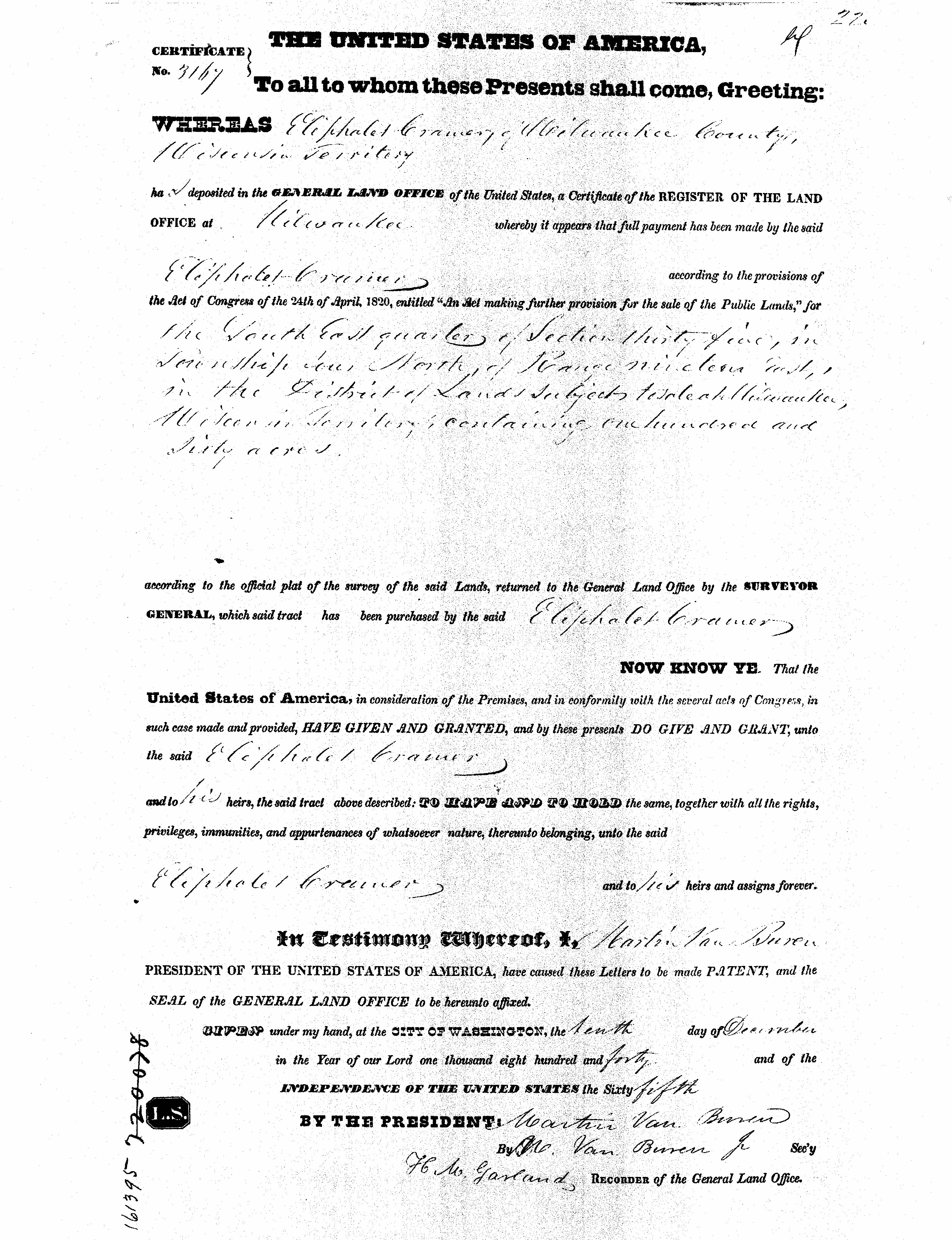
March 9, 1839 – Chapman and Barnes hired Eliphalet Cramer, of Milwaukee, to be their agent. Cramer was a wealthy gentleman and venture capitalist. He reportedly had impeccable credentials as evidenced by his affiliation with various businesses, a hospital, and lending banks. He too emigrated from Waterford, New York. Cramer paid $400 ($13,347 in 2024 dollars) for the 320 acres and transferred the deed with a mortgage to Chapman and Barnes for $1,200 ($40,042 in 2024 dollars). Today, this would be the approximate area bounded by Center Street (west) to Milwaukee Street (east) and St. Thomas Cemetery/Whitford Park (south) and Oak Lodge (north – near Harbor Heights subdivision).
The minimum size land patent available at the time was 80 acres, one half of a quarter section. Barnes and Chapman wanted the east half of section 35, Township 4, Range 19. The township established in the county of Racine, was known at the time as – Town of Rochester.
December 10, 1840 – Land patents were signed by President Martin Van Buren naming Cramer as the owner, even though he acted as agent for the others as well as his own interest. When he spoke for the land, he purchased a total of 14 land patents totaling 1,788 acres in Township 4 of Racine County for $2,235.
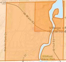
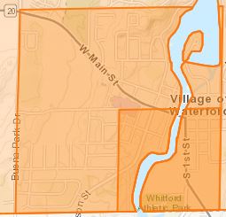
Overlays of Sections with Current Street Names, Waterford ARCGIS.
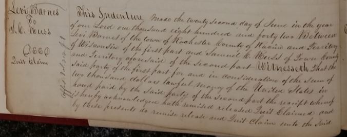
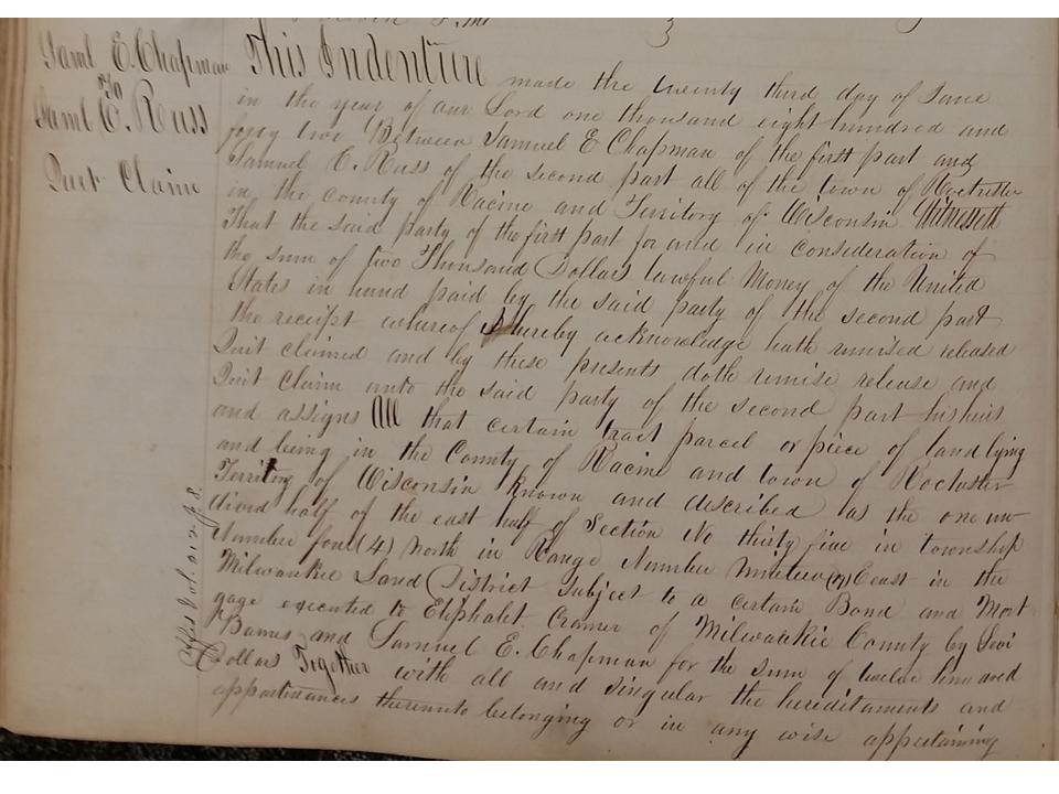
June 22, 1842 – Barnes sells his rights of the east half-section 35, plus parts of sections 24 and 34, in Township 4, Town of Rochester, to his son-in-law, Samuel C. Russ, for $2,000. The deed lists “undivided property” which means that it was not an outright sale but a shared interest in the property, 50/50.
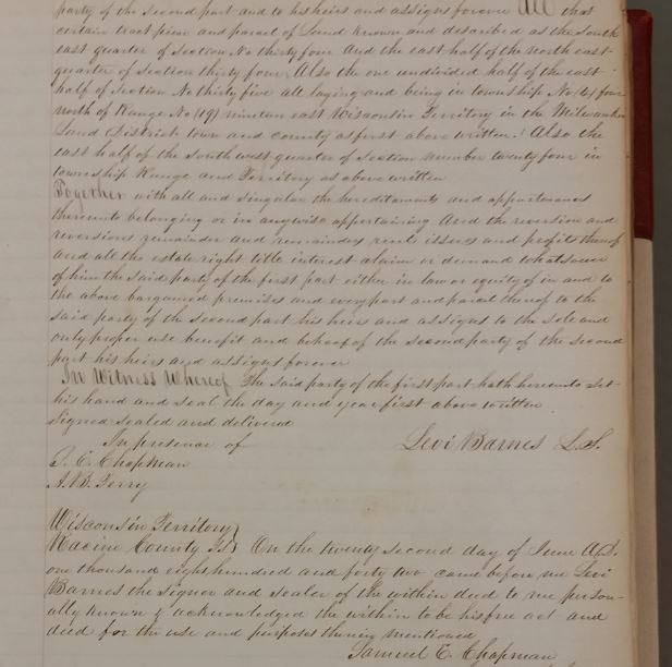
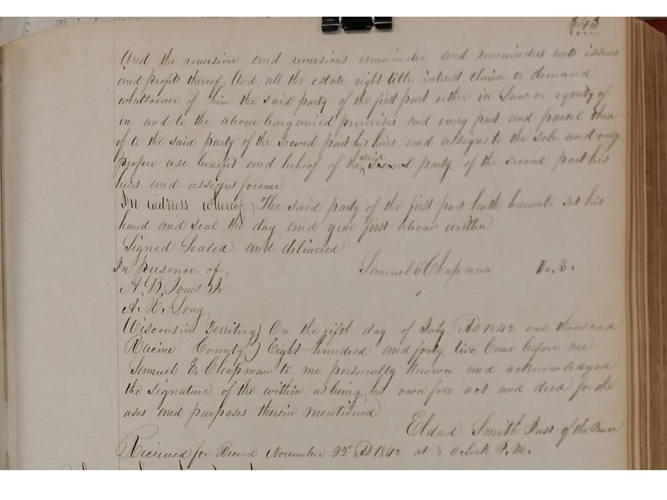
June 23, 1842 – Chapman sells his undivided property rights of the east half section of section 35, Town of Rochester, for $2,000 to his brother-in-law Samuel C. Russ. (They married Barnes’ sisters)
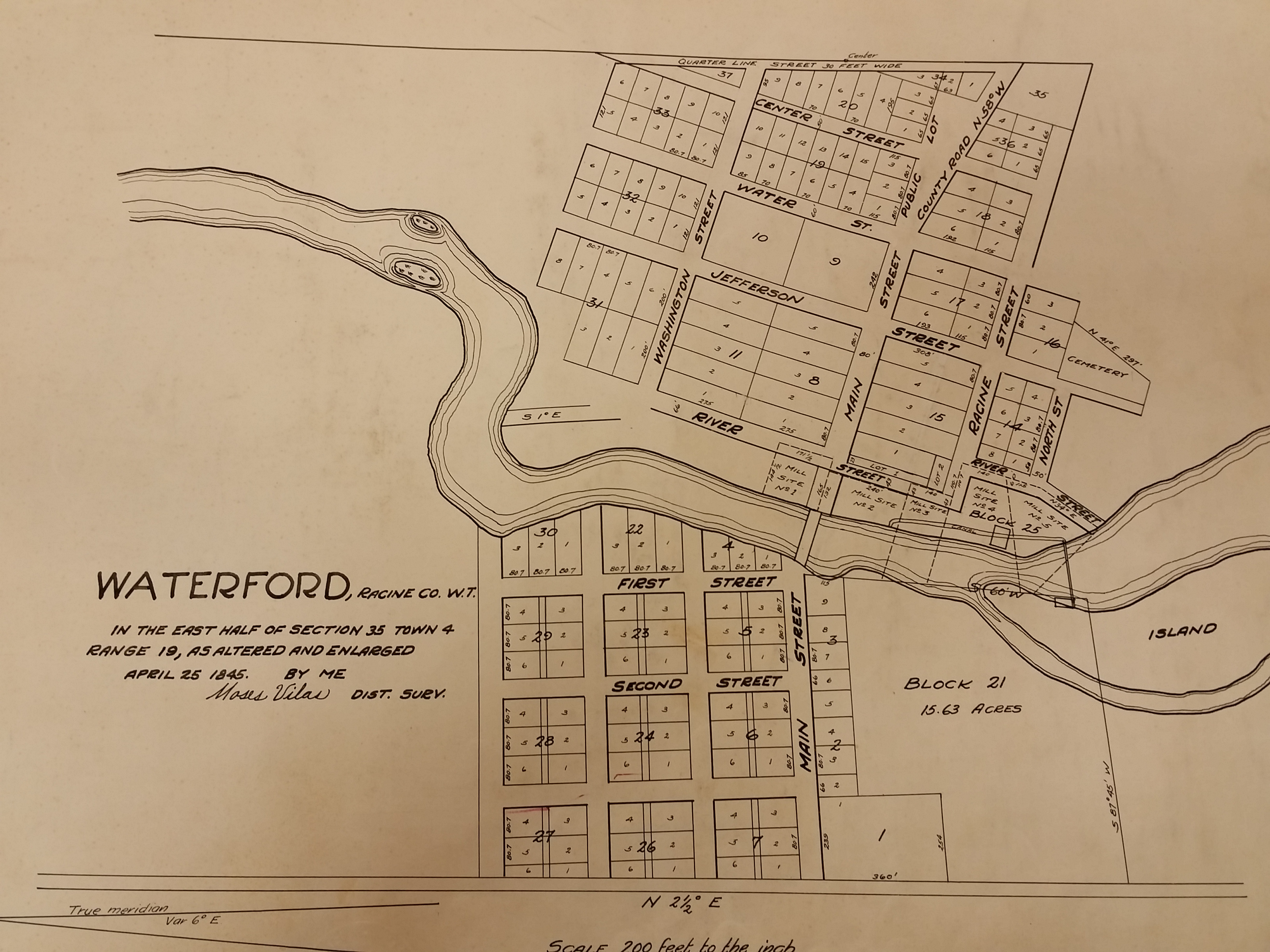
September 1842 – The village is surveyed by Moses Vilas, County Surveyor for Russ. It was notarized and filed by Chapman, Justice of the Peace, December 2, 1842. Streets and block numbers were assigned to “The Village of Waterford”. The reference to “Village” was not used as a legal definition, but as a reference to a defined community of streets, blocks, and lots.
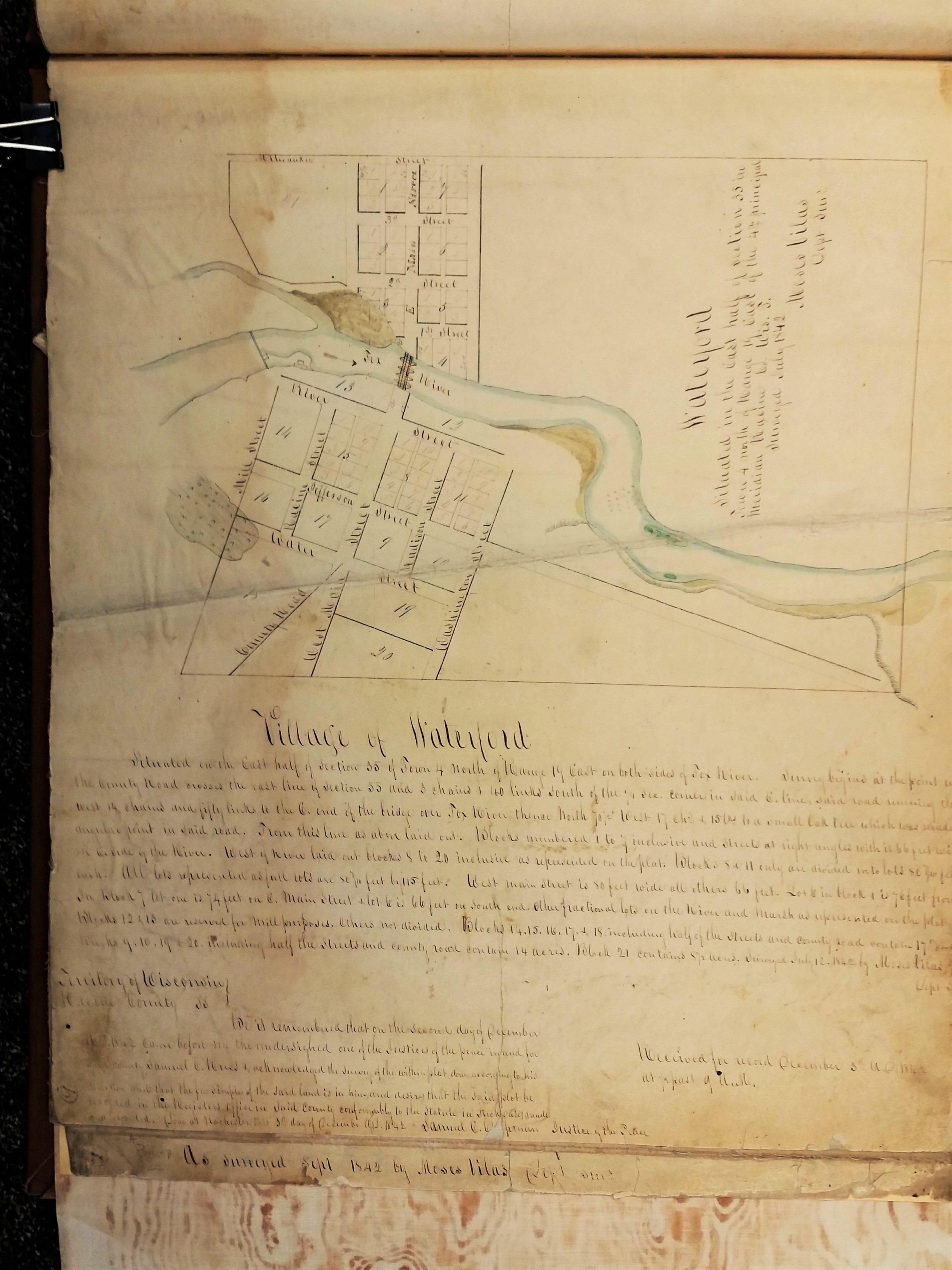
It is the author’s opinion that it would be mere coincidence or a product of folklore that Waterford would be named for a narrow spot in the river where it was “easy to ford”, or, crossover. Mr. Cramer, original purchaser of the land tract, was from Waterford, New York. Chapman was from Saratoga Lakes, a settlement not far from Waterford. It seems reasonable, with their business relationship, to name the new village “Waterford”, a common practice of the settlers naming their settlements after the area from which them came.4 It is coincidental that it was a convenient place to “ford” the river. This is confirmed in several additional documents.6, 10, 11
February 1843 – Twelve more blocks were added to the original survey. Note the location of Cemetery on Jefferson St. The lot numbers in a number of blocks were re-surveyed to a larger area, i.e.: Block 8, 11, and 15.

April 25, 1845 – Final additions were made to the survey and remained that way for many years.
January 18, 1847 – The Territorial Legislature is petitioned to form the Town of Waterford. This would separate the town from the Town of Rochester. (Document courtesy of Burlington Historical Society)

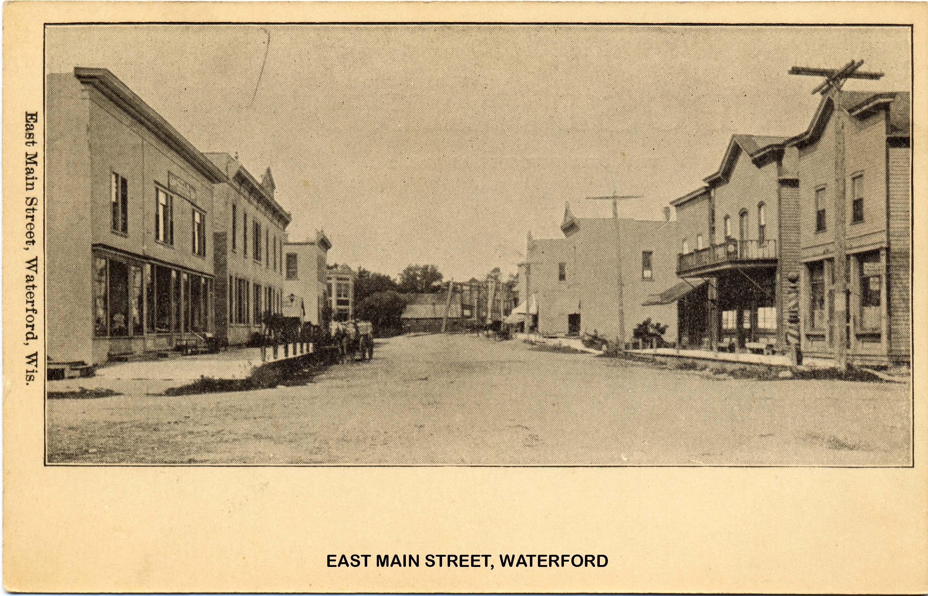
In the early days of the State, it was common to call a settlement with streets and businesses within a township a “Village”. Incorporation of the Village of Waterford as a legal entity was not done until 1906.
Interesting factoids of Waterford History ca. late 1830s and ’40s:
Common Labor – $1.50 – $2.00/day
Mechanics – $2.50 – $3.00/day
Hardwood lumber $20 – $30/M
Flour – $12 -$20/barrel
Pork – $20 – $30/barrel
Marriage License – $4.00
Plank Road from Racine to Rochester:
built during 1849
8-12″ x 4″ x 8′ long planks with earth turnoff tracks for horses to pass
cost $1600/mile to build
Toll – 1 1/2 cents/mile
(A replica of this type of road can be seen at the Wade House, a Wisconsin Historical site in Plymouth, Wisc. on Hwy. 23.)
The following excerpts are from An English Settler in Pioneer Wisconsin – Letters of Edwin Bottomley, 1842-1850, published by Wisconsin Historical Society in 1915. Bottomley settled in the English Settlement area just a few miles southeast of Waterford:
Left England 5/11/1842 – Rough Trip on Ocean – Measles spread to all kids on board
Arrived 6/17/1842
Traveled by boat with Bass Violin via Albany, Rochester, Buffalo, Toledo, Presque Isle, Manitou Is, Chicago, Milwaukee, Snail Lake (Pewaukee Lake), Yorkville, Rochester
Bought 80 acres for $40
First house was 12’x24′, 2 rooms – 12 x 14, 10 x 12
Lightning referred to as Electrical Fluid
Letters cost 27 cents to mail
Newspapers were 3 cents
Reference to estimation of 4,000 logs in the river rafting at sawmills in Waterford and Rochester
Beef, 3 cents/lb.; Pork, 2-6 cents/lb.
Bought 8-40’s of land for $1100 on Land Contract, interest of 10%.
Pair of Oxen sold for $50
Inventory from Bottomley’s Will:
Cows of inferior quality – $10 ea.
2 yr. heifers – 6$ ea.
Calves $3 ea.
Horses 16-18 yrs. $47 ea.
Small pigs $1 ea.
The complete book of Edwin Bottomley’s letters can be accessed by clicking on the reference #12 link below or at the Burlington Public Library.
From this point in time, click on the MAIN MENU to follow the development of individual properties, sites, events, and the history of our founders.
Lead Researcher: Robert E. Gariepy, Sr.
NOTE: Should the reader have further documentation to enhance the content of this web page, please contact the Lead Researcher through email at: waterfordwiheritage@gmail.com. We are particularly interested in pictures or historic artifacts that may be shared. Credit will be given.
Sources:
- The History of Racine and Kenosha Counties, Wisconsin, Chicago: Western Historical Company, 1879. Waterford Library History Room.
- Commemorative Biographical Record of Prominent and Representative Men of Racine and Kenosha Counties Wisconsin Containing Biographical Sketches of Business and Professional Men and Many of the Early Settled Families, Waterford Library History Room.
- Early Western Days, Wisconsin Historical Society.
- Commemorative Biographical Record. p. 491.
- John G. Gregory, A History of Old Milwaukee County, 1932, Vol.1.
- L.O. Whitman, Reminiscences, Burlington Free Press, July 25, 1906.
- Various Racine County Register of Deeds records.
- 1833 Treaty link: https://www.fcpotawatomi.com/culture-and-history/treaties/september-26-1833-treaty-of-chicago/.
- BLM GLO Records: https://glorecords.blm.gov/results./default.aspx?searchCriteria=type=patent|st=WI|cty=101|ln=%20Cramer|sp=true|sw=true|sadv=false.
10. Racine Journal Times, 11/5/1940.
11. I.R. Chapman Obituary, Waterford Post, 3/18/1915.
12. An English Settler in Pioneer Wisconsin – Letters of Edwin Bottomley, 1842 -1850, published by Wisconsin Historical Society in 1915. Archived at: http://www.archive.org/stream/englishsettlerin00bottrich#page/n7/mode/2up.
